
Today's weather at Waterville Valley Resort • 9 Days Forecast
Waterville Valley Summit
1,220 m

© GeoSphere Austria
thunderstorms
14 °C
min 13 °C
max 19 °C
max 19 °C
Today, 3 Aug 2026: Mostly cloudy with occasional showers. A chance of thunderstorms towards evening.
Show 9 Day ForecastMorning
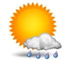 partly rain
17 °CRain: 1 l/m2Fresh snow: 0 cmWind direction: SouthWind speed: 36 km/hStorm risk: 40 %Fog risk: 35 %Rain risk: 1 %Noon
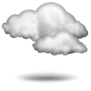 overcast
16 °CRain: 0 l/m2Fresh snow: 0 cmWind direction: SouthWind speed: 36 km/hStorm risk: 20 %Fog risk: 85 %Rain risk: 0 %Evening
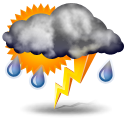 thunderstorms
16 °CRain: 4 l/m2Fresh snow: 0 cmWind direction: SouthWind speed: 40 km/hStorm risk: 55 %Fog risk: 95 %Rain risk: 4 %