
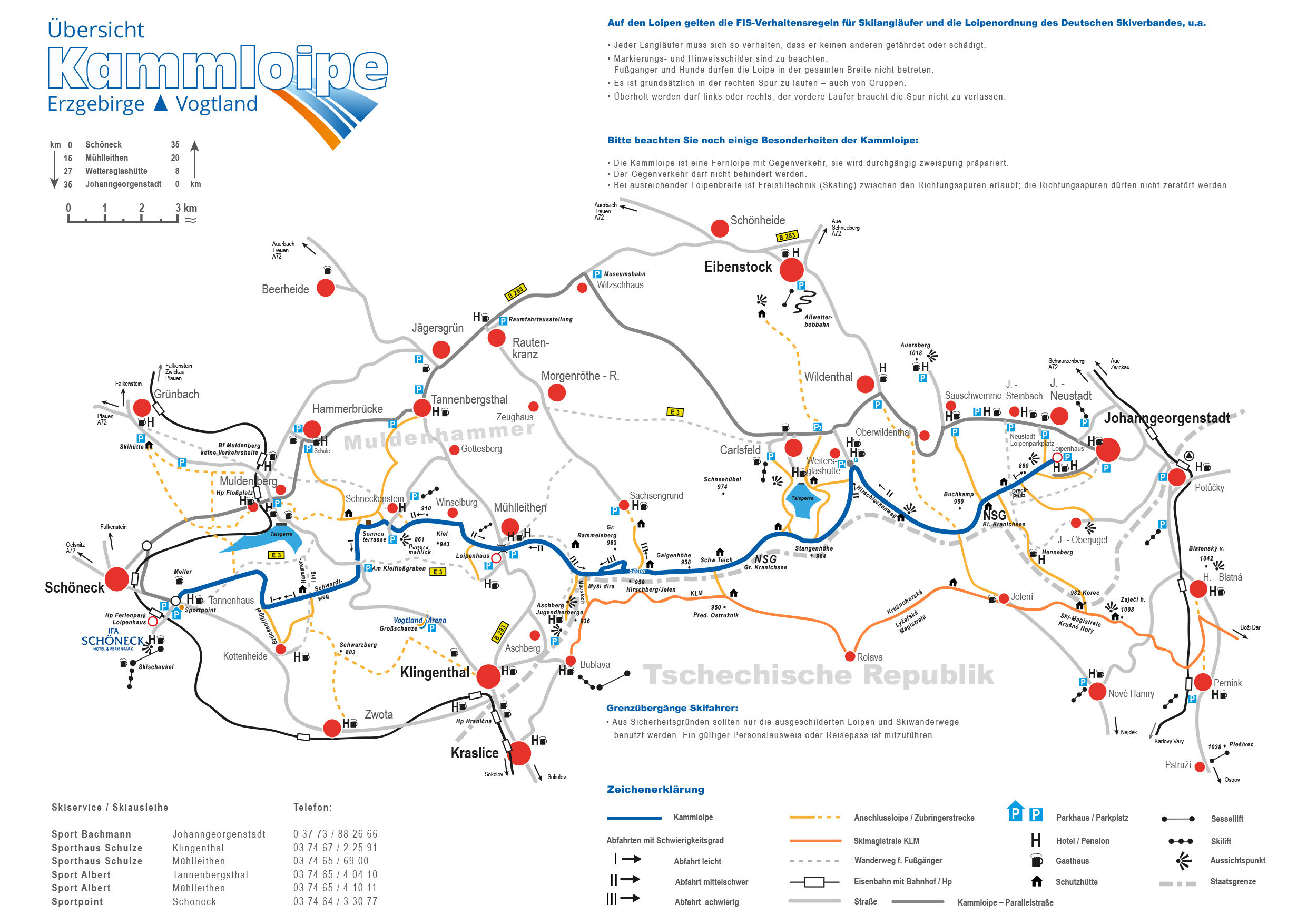
The Cross-Country Area
The Kammloipe in the Erzgebirge/Vogtland Nature Park is one of Germany's most beautiful, longest and snow-sure trails. It runs along the main ridge of the Westerzgebirge and is perfect for cross-country skiers. The trail is 36 kilometres long, but there are many different entrances and junctions along the way to shorten or diversify your tour.
The long-distance cross-country ski run is prepared in two lanes throughout and has some sections that are also suitable for skating. There are only two difficult descents (III): from the Aschberg branch in the direction of Carlsfeld (200 m) and from the Großer Rammelsberg/Hirschberg saddle in the direction of Mühlleithen, the so-called "Hirschbergsteilstück" (400 m).
Due to its high location in the closed Fichtelgebirge mountains, the cross-country ski run is situated in a perfect quiet zone of nature. With other highlights such as panoramic vantage points and sun terraces, the Kammloipe is a lasting experience for all passionate winter sports enthusiasts.
The Most Beautiful Tracks
Pretty corner
The start of the trail is on the main watershed of the Erzgebirge at 777 metres above sea level. It takes you from Schöneck first through the headwaters of the Red Mulde to the cross-country ski trail "Brückenflügel" on 5.3 kilometres of the route. Here is the junction to the connecting track to Kottenheide.
Turn left onto the Fernloipe and cross the high valley of the White Mulde. After an ascent of 500 metres you will reach the refuge "Am Hämmerling" on 6.6 kilometres. There a free style section begins up to the parking lot "Am Kielfloßgraben" at the street Muldenberg in Klingenthal. After the parking lot there is an additional skating area next to the track.
Snail stone
An ascent into the Schneckenstein area takes you to the south side of the ridge. On 10.1 kilometres there is a sun terrace and an emergency base. There you can also expect a fantastic view over the Vogtland and Czech mountain environment as far as Bavaria. The "panoramic view" is signposted from the cross-country ski run. Then the branch to the famous Topas rock follows, which brings you back to the north side. Nearby is the settlement Schneckenstein, where there is a tourist accommodation.
Millleads
Past the Waldweiler Winselburg you reach the ski village Mühlleithen. Here you can find refreshments, a cross-country ski run house, large parking spaces and ski service. The trail narrows to a few metres up to the Aschberg junction. Here are also the steepest climbs and descents. The next difficult steep descent (III) on the trail leads to the left and immediately afterwards over a strenuous ascent to the saddle Großer Rammelsberg/Hirschberg (19 km, 935 m).
Via the source area of the Great Pyra and the Wilzsch, the cross-country ski trail becomes a wide plateau again. Here you reach the highest point of the trail: the Galgenhöhe at 958 meters. On both sides there is a high moor, which is under nature protection. The Kammloipe makes a decisive contribution to the conservation of flora and fauna.
Carlsfeld
A few small climbs and descents later, on 24 kilometres of the trail, you come to another refuge. Here the Carlsfelder connecting track branches off. You follow a longer descent and reach the Weitersglashütte at 882 meters, where you can turn in.
Johanngeorgenstadt
The last section of the trail is again suitable for freestyle. The branches to Wildenthal, Jeleni, Sauschwemme and to the Czech Ski-Magistrale follow. After the "Dreckpfütz" trail spider, the cross-country trail leads to a descent to the cross-country ski run house in Johanngeorgenstadt and on to a flat connecting trail to the Johanngeorgenstadt-Neustadt car park. There you have completed the 36 kilometres of the trail.
Interesting facts
- Offering 35 km cross-country trails, Kammloipe is among the 10 largest Cross-Country Skiing Areas in Saxony.
- Kammloipe is among the 15 best rated Cross-Country Skiing Areas in Germany.
- Elevated between 739 m and 958 m, the Cross-Country Skiing Area is among the 5 highest elevated Cross-Country Skiing Areas in Saxony.
- Snow coverage is usually best during February, offering an average snow depth of 37 cm at summit elevation and 14 cm at the base. Therefore Kammloipe is among the 5 cross-Country Skiing Areas with best snow conditions in Saxony.
Getting Here
From Leipzig you take the B95 and the A72. At exit 7-Plauen-Ost change to the B173 in the direction of Falkenstein. Turn right onto the B169 and continue on Poppengrüner Str./S301. Turn right again and follow Schönecker Str./Falkensteiner Str. to Schöneck/Vogtland.


