The Cross-Country Area
Goms - a cross-country skiing Eldorado of the Alps
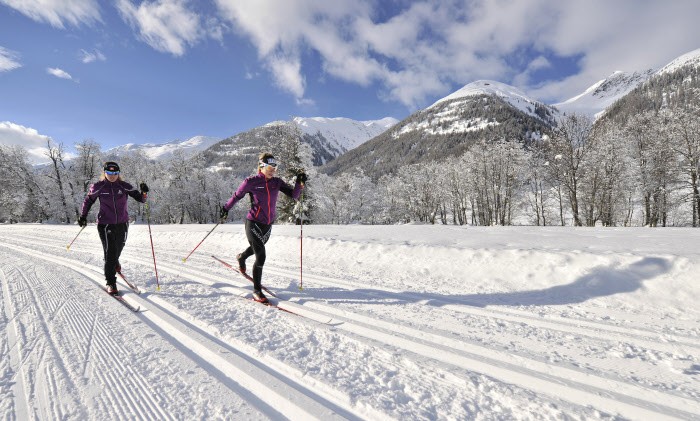
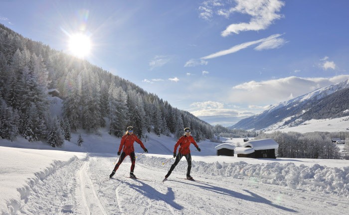
The sunny high valley of Goms in the Swiss Oberwallis with its long cross-country skiing tradition is a central meeting point for Nordic winter sports enthusiasts. The Goms cross-country ski trail connects twelve quaint villages from Oberwald to Niederwald on around 90 kilometres of perfectly groomed trails. Thanks to its location at 1,300 metres, the wide valley of the Rhone, framed by mighty three-thousand-metre peaks, is regarded as guaranteed snow.
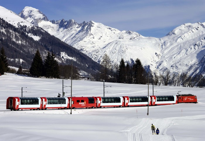
From November to early April, cross-country skiers can explore the alpine high valley from Lax to Gletsch at the foot of the Rhonegletscher. The numerous Goms train stations are all located along the Matterhorn-Gotthard line, which provides easy access to the cross-country network. This allows cross-country skiers to glide through the wintry landscape at their leisure and be brought back to their starting point comfortably by train. For beginners and all those who want to improve their technique, the teams of the local cross-country skiing schools are available.
International Gommer Run
With more than 1,900 participants from twelve nations, the International Gommerlauf is one of the most traditional cross-country races in Switzerland. Together with nine other popular races, it is also part of Swiss-Loppet. Within the framework of the Gommerlauf, the marathon or half-marathon distance can be run.
The Most Beautiful Tracks
The Goms trail is divided into the following sections.
Rottenloipe (26 km, easy)
On the 26 kilometre long Rottenloipe, cross-country skiing enthusiasts in particular will get their money's worth. The route at an average altitude of 1,300 metres leads through the picturesque landscape from Oberwald along the Rotten to Niederwald.
Hangloipe (27 km, medium)
The 27-kilometer-long slope also runs from Oberwald to Niederwald. However, it leads along the shady north slope and is more suitable for sporty runners with its slight inclines.
Sonnenloipe (8 km, easy)
A highlight for connoisseurs is the eight-kilometre-long sun trail on the right bank of the Rhone. As the name suggests, Nordic winter sports enthusiasts can enjoy a lot of sunshine on the route from Obergesteln to Münster.
Waldloipe/Pischäloipe (4 km, medium)
The four kilometre circuit through the Pischäwald has its starting and finishing point in Oberwald.
Night trail (4 km, easy)
If you want to glide through the landscape after dusk, you will find a four-kilometre-long illuminated circuit between Obergesteln and Ulrichen. Cross-country skiers can do their rounds here every evening between 17:30 and 21:30 from mid-December to mid-March.
FIS racing track (5 kilometres, difficult)
Athletically ambitious cross-country skiers can train on the FIS race track at the Nordic Centre in Ulrichen. With steep climbs, rapid descents and challenging changes of direction, it offers some challenges even for professionals. On site there is a changing room, showers and toilets.
Training tracks (3 or 5 kilometres each, difficult)
Advanced cross-country skiers can also train their stamina and strength on the demanding routes between Oberwald and Obergesteln.
Dog trail (4 km, easy)
On the four kilometre long dog trail between Obergesteln and Oberwald, four-legged friends can explore the winter landscape together with their masters.
Rhonequelle (4 km, difficult, skating only)
Skaters will find an ideal route for endurance training on the snow-covered Furka Pass road between Oberwald and the Hotel-Restaurant Rhonequelle.
Interesting facts
- Offering 109.40 km cross-country trails, Goms is among the 10 largest Cross-Country Skiing Areas in Switzerland.
- The high point of the cross-Country skiing area is located at an elevation of 1,368 m.
- Snow coverage is usually best during February, offering an average snow depth of 65 cm at summit elevation and 38 cm at the base.
Video
Getting Here
By car
Coming from Bern, take the A6 to Spiez and then the main road via Kandergrund to Visp. From there the B19 leads to Obergoms. Coming from Martigny you follow the A9 to Visp/Brig and also take the B19 into the high valley. If you arrive via Lucerne or Lugano, follow the A2 to Andermatt and drive via the B19/the Furka base tunnel to Obergoms.
By public transport
The Goms is located on the route of the Glacier Express/the Matterhorn-Gotthard Railway and can therefore be easily reached by train.