The Cross-Country Area
Between Heubach and Masserberg there is a network of 60 kilometres of cross-country ski trails. The cross-country parks in Heubach and Masserberg as well as the cross-country ski run Friedrichshöhe are prepared for the classic as well as the skating style. Classic cross-country skiers will also find longer, more demanding routes. A skating trail runs around the Fehrenberg. Every Tuesday and Thursday the Loipengarten in Masserberg is illuminated from 5 p.m. onwards.
The Most Beautiful Tracks
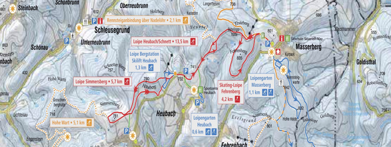
- Heubach ski lift top station: easy - 1,3 km - classic
- Friedrichshöhe: easy - 16,7 km - skating/classic
- Loipengarten Heubach: easy- 0,6 km - skating/classic
- Loipengarten Masserberg: easy - 1,1 km - skating/classic
- Heubach/Schnett: medium -13,5 km - classic
- Simmersberg: medium - 13,5 km - classic
- Rennsteig 14 Hoher Stock-Dreistromstein: medium - 15,9 km - classic
- Skating track Fehrenberg: medium - 4,2 km - skating
Interesting facts
- Offering 59 km cross-country trails, Masserberg - Heubach is among the 5 largest Cross-Country Skiing Areas in Thuringia.
- The highest point of the track is 744 m above sea level.
- Snow coverage is usually best during February, offering an average snow depth of 32 cm at summit elevation and 30 cm at the base.
Getting Here
Masserberg is located about 40 kilometers southeast of Suhl. Parking is available in Masserberg directly next to the Rennsteig cross-country ski run or at the Heubach ski area and the Heubach cross-country ski run garden.
Travel Deals & Tips
Advertisement